Photos
Enter a word or phrase to perform a general search across all records in the Photos catalog. You can also browse records in the catalog without performing a search.
Search Tips
- Searches are not case sensitive.
- Searching for multiple words connects them with OR by default. Matching records can contain any of the words.
- Connect multiple words with AND if you only want to see records containing both words.
- Use quotation marks to search for a phrase.
- Place an asterisk (*) at the end of a word as a wildcard.
Photo Results
1819 results found. Records searched: 8823
-
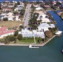
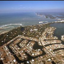
Negative - 2013-01-049
Color aerial photographic negative of a residential area on Marco Island. S. Barfield Dr., Inlet Dr., Dogwood Dr., Hawaii Cir., and Granada Dr. visible. Barfield Bay in the background. Roberts Bay in the foreground.
Record Type: Photo
-
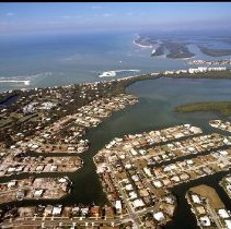
Negative - 2013-01-050
Color aerial photographic negative of a residential area on Marco Island. Caxambas Ct., McIlvaine Ct., Eubanks Ct., Heights Ct., S. Barfield Dr., and Pettit Ct. visible. Barfield Bay in the background.
Record Type: Photo
-
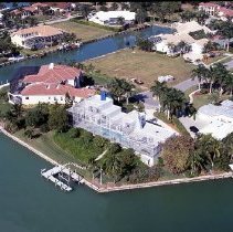
Negative - 2013-01-051
Color aerial photographic negative of a residential area on Marco Island. Eubanks Ct. visible.
Record Type: Photo
-
Negative - 2013-01-052
Color aerial photographic negative of a residential area on Marco Island. Eubanks Ct., Doxsee Terrace, and W. Copeland Dr. visible.
Record Type: Photo
-
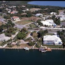
Negative - 2013-01-053
Color aerial photographic negative of the front entrance to the Hideaway Beach Club on Marco Island. Hideaway Beach and the Gulf of Mexico in the background.
Record Type: Photo
-
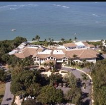
Negative - 2013-01-054
Color aerial photographic negative of the back of the Hideaway Beach Club on Marco Island. Hideaway Beach and the Gulf of Mexico in the foreground.
Record Type: Photo
-
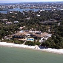
Negative - 2013-01-055
Color aerial photographic negative of Hideaway Beach and Coconut Island on Marco Island. Condo buildings visible on the proper right side.
Record Type: Photo
-
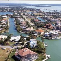
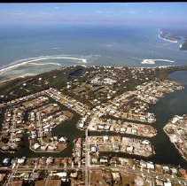
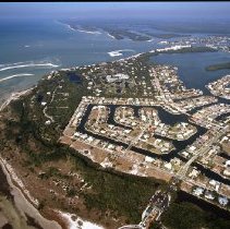
Negative - 2013-01-056
Color aerial photographic negative of Hideaway Beach and the surrounding residential areas on Marco Island. Royal Marco Way, Seabreeze Dr., Wild Orchard Ln., Sand Dune Dr., Sea Oats Ct., Hideaway Cir. N., N. Kendall Dr., Live Oak Ln., Hideaway Cir. E., Gumbo Limbo Ln., S. Beach Dr., Hideaway Cir. W., Waterside Dr., Gate House Ct., Renard Ct., Maunder Ct., Thorpe Ct., Gray Ct., Richards Ct., Austin Ct., Parkhouse Ct., Clifton Ct., Hernando Dr., Ti...
Record Type: Photo
-
Negative - 2013-01-057
Color aerial photographic negative of Hideaway Beach and the surrounding residential areas on Marco Island. Royal Marco Way, Seabreeze Dr., Wild Orchard Ln., Sand Dune Dr., Sea Oats Ct., Hideaway Cir. N., N. Kendall Dr., Live Oak Ln., Hideaway Cir. E., Gumbo Limbo Ln., S. Beach Dr., Hideaway Cir. W., Waterside Dr., Gate House Ct., Renard Ct., Maunder Ct., Thorpe Ct., Gray Ct., Richards Ct., Austin Ct., Parkhouse Ct., Clifton Ct., Hernando Dr., Ti...
Record Type: Photo
-
Negative - 2013-01-058
Color aerial photographic negative of Hideaway Beach and the surrounding residential areas on Marco Island. Royal Marco Way, Seabreeze Dr., Wild Orchard Ln., Sand Dune Dr., Sea Oats Ct., Hideaway Cir. N., N. Kendall Dr., Live Oak Ln., Hideaway Cir. E., Gumbo Limbo Ln., S. Beach Dr., Hideaway Cir. W., Waterside Dr., Gate House Ct., Renard Ct., Maunder Ct., Thorpe Ct., Gray Ct., Richards Ct., Austin Ct., Parkhouse Ct., Clifton Ct., Hernando Dr., Ti...
Record Type: Photo
-
Negative - 2013-01-059
Color aerial photographic negative of Hideaway Beach and the surrounding residential areas on Marco Island. Royal Marco Way, Seabreeze Dr., Wild Orchard Ln., Sand Dune Dr., Sea Oats Ct., Hideaway Cir. N., N. Kendall Dr., Live Oak Ln., Hideaway Cir. E., Gumbo Limbo Ln., S. Beach Dr., Hideaway Cir. W., Gate House Ct., Renard Ct., Maunder Ct., Thorpe Ct., Gray Ct., Richards Ct., Austin Ct., Parkhouse Ct., Clifton Ct., Hernando Dr., Tigertail Ct., Pl...
Record Type: Photo
-
Negative - 2013-01-060
Color aerial photographic negative of Hideaway Beach and the surrounding residential areas on Marco Island. Royal Marco Way, Seabreeze Dr., Wild Orchard Ln., Sand Dune Dr., Sea Oats Ct., Hideaway Cir. N., N. Kendall Dr., Live Oak Ln., Hideaway Cir. E., Gumbo Limbo Ln., S. Beach Dr., Hideaway Cir. W., Waterside Dr., Gate House Ct., Renard Ct., Maunder Ct., Thorpe Ct., Gray Ct., Richards Ct., Austin Ct., Parkhouse Ct., Clifton Ct., Hernando Dr., Ti...
Record Type: Photo
-
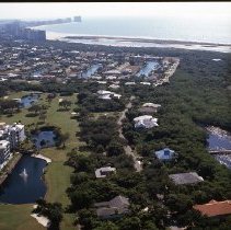
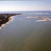
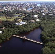
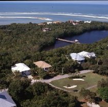
Negative - 2013-01-061
Color aerial photographic negative of the pedestrian bridge over a small body of water in the Hideaway area of Marco Island. Hideaway golf course and residential areas in the background.
Record Type: Photo
-
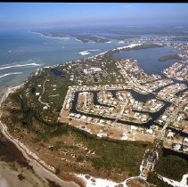
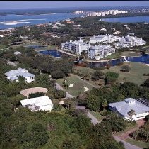
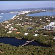
Negative - 2013-01-062
Color aerial photographic negative of the Habitat at Hideaway condo buildings and houses along the Hideaway golf course. Other condos in Hideaway and Isles of Capri in the background.
Record Type: Photo
-
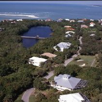
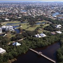
Negative - 2013-01-063
Color aerial photographic negative of houses along the Hideaway golf course on Hideaway Cir. W. Pedestrian bridge over a small body of water in the center. Tigertail Beach in the background.
Record Type: Photo
-
Negative - 2013-01-064
Color aerial photographic negative of condo buildings and houses along the Hideaway golf course. Part of the Habitat at Hideaway condo buildings visible. Pedestrian bridge over a small body of water in the foreground. Other Hideaway condo buildings, Isles of Capri, and Old Marco in the background.
Record Type: Photo
-
Negative - 2013-01-065
Color aerial photographic negative of houses along the Hideaway golf course. Pedestrian bridge over a small body of water in the center. Other houses and Tigertail Beach in the background.
Record Type: Photo
-
Negative - 2013-01-066
Color aerial photographic negative of condo buildings and houses along the Hideaway golf course. Pedestrian bridge over a small body of water in the foreground. Other residential areas in the background.
Record Type: Photo
-
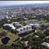
Negative - 2013-01-067
Color aerial photographic negative of the Habitat at Hideaway condo buildings and houses along the Hideaway golf course. Other residential areas in the background.
Record Type: Photo
-
Negative - 2013-01-068
Color aerial photographic negative of condo buildings and houses along the Hideaway golf course. Hideaway Cir. W., Colonial Dr., Spinnaker Dr., Blackmore Ct., Henderson Ct., and Cottage Ct. visible. Tigertail Beach and the shoreline in the background.
Record Type: Photo