
Photo Record
Images
Metadata
Object Name |
Negative |
Catalog Number |
2013-01-058 |
Description |
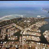
Color aerial photographic negative of Hideaway Beach and the surrounding residential areas on Marco Island. Royal Marco Way, Seabreeze Dr., Wild Orchard Ln., Sand Dune Dr., Sea Oats Ct., Hideaway Cir. N., N. Kendall Dr., Live Oak Ln., Hideaway Cir. E., Gumbo Limbo Ln., S. Beach Dr., Hideaway Cir. W., Waterside Dr., Gate House Ct., Renard Ct., Maunder Ct., Thorpe Ct., Gray Ct., Richards Ct., Austin Ct., Parkhouse Ct., Clifton Ct., Hernando Dr., Tigertail Ct., Plantation Ct., Shell Ct., Taylor Ct., Blackmore Ct., Spinnaker Dr., Henderson Ct., Cottage Ct., Colonial Dr., Hideaway Cir. S., Sea Lavender Ln., Wild Cherry Ln., Lantana Ln., and Coco Plum visible. Tigertail Beach in the proper right top corner. |
Place |
Marco Island, Florida |
Date |
ca. 2004 |
Photographer |
Howe, Barry |
Medium |
Photographic Negative |
Search Terms |
Hideaway Beach |