Archives
Enter a word or phrase to perform a general search across all records in the Archives catalog. You can also browse records in the catalog without performing a search.
Search Tips
- Searches are not case sensitive.
- Searching for multiple words connects them with OR by default. Matching records can contain any of the words.
- Connect multiple words with AND if you only want to see records containing both words.
- Use quotation marks to search for a phrase.
- Place an asterisk (*) at the end of a word as a wildcard.
1498 results found. Records searched: 1498
-
-
Story - 2011-04-480
Handwritten. 5 pages, single sided. Entitled "Marjorie, Nita and Bess and The Little Fishes" by Mary J. Olds. Pages 2-4 have a stamp "Feb 6 1907"
Record Type: Archive
-
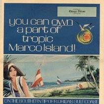
Supplement, Newspaper - 2016-15-003
8-page supplemental newspaper to the Chicago Tribune regarding Marco Island. Front features a color image of a woman wearing a white headband on the proper right side. Two sailboats, two people, and a beach in center and proper left side. Text on the cover reads "You Can Own a Part of Tropic Marco Island!, On the Southern Tip of Florida's Gulf Coast." Inside features history and information about Marco Island. Color images appear frequentl...
Record Type: Archive
-
Supplement, Newspaper - 2016-30-001
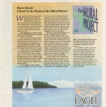
24 bi-fold newspaper weekly supplements from the Marco Eagle for "The Mural Project." Each page includes information about a different place or characteristic about Marco Island along with a cut-out print of a section of a mural [2006-04-001].
Record Type: Archive
-
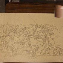
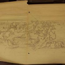
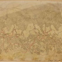
Survey, Land - 2000-08-001
"10:40 AM FEB 22. 1927". Locality: Cape Romano - Little Marco Pass. Lithographic Print drawn from aerial photographs.
Record Type: Archive
-
Survey, Land - 2000-08-002
"10:40 AM FED 22. 1927". Locality: Cape Romano - Little Marco Pass and Gulf of Mexico-> Addision Bay. Lithographic Print drawn from aerial photographs. Compilation by US Coast Guard and Geodetic Survey, Photographs by US Army Air Corps.
Record Type: Archive
-
Survey, Land - 2000-08-003
Printed lithographic image, drawn from US Army Air Corps aerial photographs. Tiger Key to Coon Key. Time and Date of Photographs: 5pm Feb 18th 1927.
Record Type: Archive
-
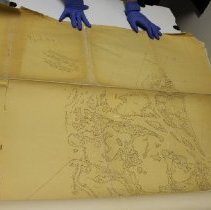
Survey, Land - 2003-06-001
Lithographic print with handmade notes. Locality Cape Romano-Little Marco Pass. "10:40 AM FEB 22 1927". Seems to have a duplicate print in the collection (see objects through browse). This particular one is in very bad shape, with torn creases, brittle paper, and major tears at the top and bottom of map.
Record Type: Archive
-
Survey, Land - 2003-06-005
Lithographic print with handmade notes; handwritten "Tarpon Bay & Bear Point Creek". Locality Cape Romano-Little Marco Pass. "10:40 AM FEB 22 1927."
Record Type: Archive
-
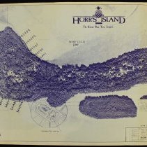
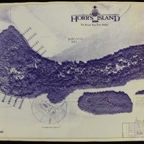
Survey, Land - 2013-04-013
Booklet of 5 aerial photographs of Horr's Island and Barfield Bay. Cover features an image of the land in between Barfield Bay and Caxambas Pass. Across the top reads "Horr's Island." Stamp in the proper left bottom corner reads "Printed Jun 28 1990." Text in the proper left bottom corner reads "Lot Sales Exhibit, Horr's Island." Booklet was made for Key Marco Development by Wilson Miller Barton Soll & Peek, Inc.
Record Type: Archive
-
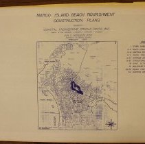
Survey, Land - 2013-04-014
30-page booklet of construction plans. Cover reads "Marco Island Beach Nourishment Construction Plans, Prepared by Coastal Engineering Consultants, Inc., February 1989." Below the text is a map of Marco Island including street names. Index on the proper left side. Stamp in the proper left bottom corner reads "Mar 15 1989, Preliminary." Text in the proper left bottom corner reads "Sheet 1 of 30."
Record Type: Archive
-
Survey, Land - 2013-04-019
Booklet of 5 aerial photographs of Horr's Island and Barfield Bay. Cover features an image of the land in between Barfield Bay and Caxambas Pass. Across the top reads "Horr's Island." Stamp in the proper left bottom corner reads "Printed Jun 28 1990." Text in the proper left bottom corner reads "Lot Sales Exhibit, Horr's Island." Booklet was made for Key Marco Development by Wilson Miller Barton Soll & Peek, Inc.
Record Type: Archive
-
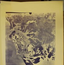
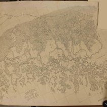
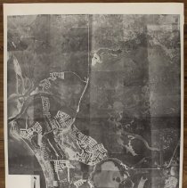
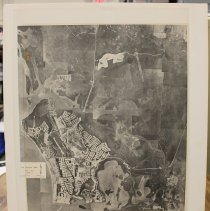
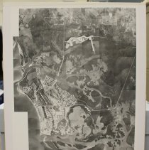
Survey, Land - 2013-04-338
Black and white aerial survey of Marco Island, Isles of Capri, and Goodland. Jolley Bridge and Goodland Bridge visible. Marco Island is under development with several areas dredged. Part of the beachfront properties being developed. Text in the proper right bottom corner reads "Marco Island, 1" = 2175', Flown Dec. 11, 1971, Dec. 16, 1971, Pan American Surveys, Inc., Form 09-005-20, AP 3315 (K)(C), Mich. 872, N.Y.A. 874-73." Image description o...
Record Type: Archive
-
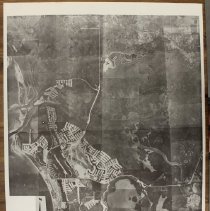
Survey, Land - 2013-04-339
Black and white aerial survey of Marco Island, Isles of Capri, and Goodland. Jolley Bridge and Goodland Bridge visible. Marco Island is under development with several areas dredged. Part of the beachfront properties being developed. Text in the proper right bottom corner reads "Marco Island, 1" = 2175', Flown Dec. 11, 1971, Dec. 16, 1971, Pan American Surveys, Inc., Form 09-005-20, AP 3315 (K)(C), Mich. 872, N.Y.A. 874-73." Image description o...
Record Type: Archive
-
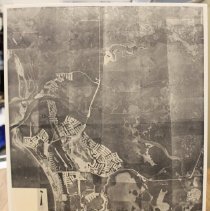
Survey, Land - 2013-04-340
Black and white aerial survey of Marco Island, Isles of Capri, and Goodland. Jolley Bridge and Goodland Bridge visible. Marco Island is under development with several areas dredged. Part of the beachfront properties being developed. Text in the proper right bottom corner reads "Marco Island, 1" = 2175', Flown Dec. 11, 1971, Dec. 16, 1971, Pan American Surveys, Inc., Form 09-005-20, AP 3315 (K)(C), Mich. 872, N.Y.A. 874-73." Image description o...
Record Type: Archive
-
Survey, Land - 2013-04-341
Black and white aerial survey of Marco Island, Isles of Capri, and Goodland. Jolley Bridge and Goodland Bridge visible. Marco Island is under development with more dredged areas. Part of the beachfront properties being developed. Text in the proper right bottom corner reads "The Deltona Corp., Marco Beach, Collier Co., Date of Aerials: Dec. 28, 1972, Aerials by P.A.S., Mosaic Scale, 1" = 2,300'." Image description on a post-it note on the back...
Record Type: Archive
-
Survey, Land - 2013-04-342
Black and white aerial survey photograph of Marco Island, Isles of Capri, Goodland, and south Naples. Jolley Bridge and Goodland Bridge visible. Marco Island is under development with several dredged areas. Image description on a post-it note on the back: "Aerial view including Isles of Capri to the right all Marco Island & Goodland - upper left, no date, 12/28/72." Survey is glued to a heavy board.
Record Type: Archive
-
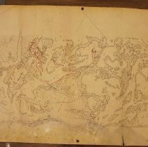
Survey, Land - 2014-14-035
Lithographic print from compilation of aerial photographs. Locality Tiger Key - Coon Key. Reads "5 PM FEB 18, 1927". Contains writing in red ink with names of bays added to the map - see photographs.
Record Type: Archive
-
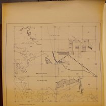
Survey, Land - 2014-14-038
Collier County land survey. Text reads "Collier County Township 51S, Range 26E, Book 26." Survey shows Tamiami Trail, Rookery Bay Wildlife Sanctuary, Henderson Creek, Marco Beach - Unit 24, and Tarpon Creek.
Record Type: Archive
-
Survey, Land - 2014-36-001
Black and white aerial photograph of Marco Island, Goodland, Isles of Capri, south Naples, and Fakahatchee State Park (currently). Shows several areas of development on Marco Island. Most likely used for land surveying or zoning. Text in the proper left bottom corner reads "Marco Island, Fla."
Record Type: Archive