
Archive Record
Images
Metadata
Object Name |
Survey, Land |
Catalog Number |
2013-04-338 |
Description |
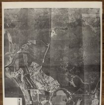
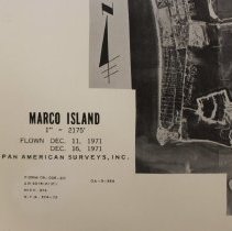
Black and white aerial survey of Marco Island, Isles of Capri, and Goodland. Jolley Bridge and Goodland Bridge visible. Marco Island is under development with several areas dredged. Part of the beachfront properties being developed. Text in the proper right bottom corner reads "Marco Island, 1" = 2175', Flown Dec. 11, 1971, Dec. 16, 1971, Pan American Surveys, Inc., Form 09-005-20, AP 3315 (K)(C), Mich. 872, N.Y.A. 874-73." Image description on a post-it note on the back: "Aerial view, Dec. 11 & 16, 1971, Marco Island, Lower rt - Goodland, upper left Isles of Capri, upper rt - Marco Shore (2 copies)." Survey is glued to a yellow posterboard. |
Date |
12/11/1971 |
Publisher |
Pan American Surveys, Inc. |
Publication Date |
12/11/1971 |