
Photo Record
Images
Metadata
Object Name |
Transparency, Slide |
Catalog Number |
2012-01-015 |
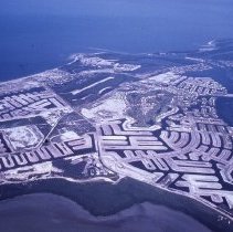
Description |
Color aerial photographic slide of Marco Island. Photograph taken from the southeast looking northwest. Dredging development throughout. Stillwater Ct., Hollyhock Ct., Dan River Ct., Calusa Ct., Cascade Ct., Coral Ct., Windbrook Ct., Angler Ct., Geranium Ct., Honduras Ave., Starfish Ct., Bluehill Ct., Acorn Ct., N. Sunset St., Channel Ct., Peach Ct., Woodbine Ct., Apataki Ct., Menorca Ct., Maywood Ct., Waterfall Ct., Barbados Ave., Polynesia Ct., Meadowlark Ct., Rockhill Ct., Grapewood Ct., Seminole Ct., Seahorse Ct., Hummingbird Ct., Gulfport Ct., Shorecrest Ct., Leeward Ct., San Marco Rd., Algonquin Ct., Madagascar Ct., Rainbow Ct., Richmond Ct., Villa Ct., Barbarosa Ct., Columbus Way, Sandhill St., Orleans Ct., Begonia Ct., and Galleon Ct. visible in the foreground. Marco Island Country Club and Marco Island Airways airstrip in the center. Jolley Bridge and Isles of Capri on the proper left side. Red stamp on the back reads "Dec 72 A7." Handwritten caption on the back reads "Delonta R.E." |
Place |
Marco Island, Florida |
Date |
12/1972 |
Medium |
Photographic Slide |
Search Terms |
Jolley Bridge Marco Island Airstrip Marco Island Airways Marco Island Country Club |